

Garmin GPSMAP 66i
| Brand | Garmin |
| Model Name | Garmin 989-1423 |
| Screen Size | 3 Inches |
| Special Feature | Interactive SOS to Search and Rescue; Satellite Texting (with Subscription); Global Navigation Satellite Systems; TOPO Maps and Satellite Imagery |
| Connectivity Technology | Bluetooth, ANT+, Wi-Fi |
| Map Type | Topographical |
| Sport | Camping & Hiking |
| Included Components | GPSMAP 66i; Access to Birdseye Satellite Imagery; USB Cable; Carabiner Clip; Documentation |
| Battery Life | 16 Hours |
| Mounting Type | Found in image, Wrist Mount |
KSh72,999.00
Garmin GPSMAP 66i
GPSMAP 66i is fitted with the best in Garmin navigation. Preloaded Garmin TOPO mapping provides detailed views of terrain contours, topographic elevations, summits, parks, coastlines, rivers, lakes and geographical points. Direct-to-device downloads of BirdsEye Satellite Imagery provide high-resolution. Photo-realistic views of your route, trailheads, clearings and more — without an annual subscription. Support for multi-GNSS combined with altimeter, barometer and compass navigation sensors lets you track and navigate in challenging environments.
General |
|
| DIMENSION | 2.5” x 6.4” x 1.4” (6.2 x 16.3 x 3.5 cm) |
|---|---|
| WEIGHT | 8.1 oz (230 g) with batteries |
| WATERPROOF | IPX7 |
| MIL-STD-810 | yes (thermal, shock, water) |
| DISPLAY TYPE | transflective color TFT |
| DISPLAY SIZE | 1.5″W x 2.5″H (3.8 x 6.3 cm); 3″ diag (7.6 cm) |
| DISPLAY RESOLUTION | 240 x 400 pixels |
| BATTERY TYPE | rechargeable, internal lithium-ion |
| BATTERY LIFE | up to 35 hours at 10-minute tracking Up to 200 hours at 30-minute tracking (power save mode) |
| MEMORY/HISTORY | 16 GB (user space varies based on included mapping) |
| INTERFACE | high speed micro USB and NMEA 0183 compatible |
Maps & Memory |
|
| PRELOADED MAPS | yes (TopoActive, routable) |
|---|---|
| ABILITY TO ADD MAPS | ✔️ |
| BASEMAP | ✔️ |
| AUTOMATIC ROUTING (TURN BY TURN ROUTING ON ROADS) FOR OUTDOOR ACTIVITIES | ✔️ |
| MAP SEGMENTS | 15,000 |
| SATELLITE IMAGERY | yes (direct to device) |
| INCLUDES DETAILED HYDROGRAPHIC FEATURES (COASTLINES, LAKE/RIVER SHORELINES, WETLANDS AND PERENNIAL AND SEASONAL STREAMS) | ✔️ |
| INCLUDES SEARCHABLE POINTS OF INTERESTS (PARKS, CAMPGROUNDS, SCENIC LOOKOUTS AND PICNIC SITES) | ✔️ |
| DISPLAYS NATIONAL, STATE AND LOCAL PARKS, FORESTS, AND WILDERNESS AREAS | ✔️ |
| EXTERNAL MEMORY STORAGE | yes (32 GB max microSD™ card) |
| WAYPOINTS/FAVORITES/LOCATIONS | 10,000 |
| COURSES | 250, 200 course points per course |
| TRACKS | 250 |
| NAVIGATION TRACK LOG | 20,000 points, 250 saved gpx tracks, 300 saved fit activities |
| ACTIVITIES | |
| NAVIGATION ROUTES | 250, 250 points per route; 50 points auto routing |
| RINEX LOGGING | ✔️ |
Sensors |
|
| GPS | ✔️ |
|---|---|
| GALILEO | ✔️ |
| BAROMETRIC ALTIMETER | ✔️ |
| COMPASS | Yes (tilt-compensated 3-axis) |
| HIGH-SENSITIVITY RECEIVER | ✔️ |
| GPS COMPASS (WHILE MOVING) | ✔️ |
Daily Smart Features |
|
| CONNECT IQ™ (DOWNLOADABLE WATCH FACES, DATA FIELDS, WIDGETS AND APPS) | ✔️ |
|---|---|
| SMART NOTIFICATIONS ON HANDHELD | ✔️ |
| ACTIVE WEATHER | ✔️ |
| VIRB® REMOTE | ✔️ |
| PAIRS WITH GARMIN CONNECT™ MOBILE | ✔️ |
Safety and Tracking Features |
|
| LIVETRACK | ✔️ |
|---|---|
Outdoor Recreation |
|
| POINT-TO-POINT NAVIGATION | ✔️ |
|---|---|
| TRACBACK® | ✔️ |
| AREA CALCULATION | ✔️ |
| FISH FORECAST | ✔️ |
| SUN AND MOON INFORMATION | ✔️ |
| XERO™ LOCATIONS | ✔️ |
| GEOCACHING-FRIENDLY | yes (Geocache Live) |
| CUSTOM MAPS COMPATIBLE | yes (500 custom map tiles) |
| PICTURE VIEWER | ✔️ |
| LED BEACON FLASHLIGHT | ✔️ |
inReach® Features |
|
| INTERACTIVE SOS | ✔️ |
|---|---|
| INREACH WEATHER | ✔️ |
| SEND AND RECEIVE TEXT MESSAGES TO SMS AND EMAIL | ✔️ |
| SEND AND RECEIVE TEXT MESSAGES TO OTHER INREACH DEVICE | ✔️ |
| EXCHANGE LOCATIONS WITH OTHER INREACH DEVICE | ✔️ |
| MAPSHARE COMPATIBLE WITH TRACKING | ✔️ |
| VIRTUAL KEYBOARD FOR CUSTOM MESSAGING | ✔️ |
| SEND WAYPOINTS TO MAPSHARE DURING TRIP | ✔️ |
| SEND ROUTE SELECTION TO MAPSHARE DURING TRIP | ✔️ |
Outdoor Applications |
|
| COMPATIBLE WITH GARMIN EXPLORE™ APP | ✔️ |
|---|---|
| GARMIN EXPLORE WEBSITE COMPATIBLE | ✔️ |
| COMPATIBLE WITH GARMIN MESSENGER APP | ✔️ |
Connections |
|
| CONNECTIONS WIRELESS CONNECTIVITY | yes (Wi-Fi®, BLUETOOTH®, ANT+®) |
|---|---|
Buy Garmin GPSMAP 66iat the best price online in Kenya from Gadget Central Ltd.
Related products
-
Mapping & GPS
Garmin eTrex 22x
Key features:
- 2.2” sunlight-readable color display with 240 x 320 display pixels for improved readability
- Preloaded with TopoActive maps with routable roads and trails for cycling and hiking
- Support for GPS and GLONASS satellite systems allows for tracking in more challenging environments than GPS alone
- 8 GB of internal memory for map downloads plus a microSD™ card slot
- eTrex 32x adds a 3-axis compass and barometric altimeter
- Battery life: up to 25 hours in GPS mode with 2 AA batteries
SKU: n/a -
Mapping & GPS
Garmin eTrex 32x
General
Physical dimensions – 5.4 x 10.3 x 3.3 cm
Display size – 3.5 x 4.4 cm; 2.2″ diag (5.6 cm)
Display resolution – 240 x 320 pixels
Display type – 2.2″ transflective, 65K colour TFT
Weight – 141.7 g (with batteries)
Battery – 2 AA batteries (not included); NiMH or Lithium recommended
Battery life – 25 hours
Water rating – IPX7
Memory/history – 8GB
SKU: n/a -
Mapping & GPS
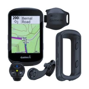
GARMIN Edge 530GPS Bundle
- Alerts (triggers alarm when you reach time, distance, HR, calories goals): yes
- Internal memory: 16 GB
- Compatible with Varia™bike radar and lights: yes
- LiveTrack: yes
- Advanced performance and power analysis, including new Time in Zone, FTP tracking, cycling-specific VO2 and recovery and cycling dynamics
- Bike trainer profile for compatible Turbo trainer data display and control
- On-device segment compatibility for dynamic and engaging in-ride competition
- Operating temperature: -20°C to +55°C
- Connected features via a smartphone: yes
- Integration with Shimano Di2 electronic shifting: yes
- Weather alerts: yes
SKU: n/a -
Mapping & GPS
Garmin eTrex® SE GPS
Brand Garmin Model Name Garmin eTrex SE Screen Size 2.16 Inches Special Feature Bluetooth Connectivity Technology Bluetooth, USB Map Type North America Sport Camping & Hiking, Outdoor Lifestyle Included Components ETrex SE handheld device, documentation Battery Life 168 Hours Mounting Type Wrist Mount SKU: n/a