Mapping & GPS
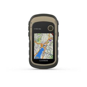
Garmin Map64 st
Outdoor features
- Hunt/fish calendar
- Sun and moon information
- Area calculation
- Compatible with Garmin Basecamp software
- Tide tables with optional Bluechart
- Smart Notification lets you wirelessly receive email, texts, and alerts from your compatible iPhone 4s or later
- Bluetooth to wirelessly transfer data between units
- ANT+ wireless compatible for use with heart rate, cadence, chirp and tempe sensor
KSh40,999.00 KSh45,000.00
Garmin Map64 st
Garmin Map64 st
Features
- 2.6-inch sunlight-readable color screen
- High-sensitivity GPS and GLONASS receiver with quad helix antenna
- Preloaded TOPO U.S. 100K maps
- 3-axis compass with barometric altimeter
- Wireless connectivity via Bluetooth technology¹ or ANT
- BirdsEye Satellite Imagery Subscription
- Utilizes GPS and GLONASS Satellites
- 3-Axis Compass
- Barometric Altimeter
Outdoor Features
- Hunt/fish calendar
- Sun and moon information
- Area calculation
- Compatible with Garmin Basecamp software
- Tide tables with optional Bluechart
- Smart Notification lets you wirelessly receive email, texts, and alerts from your compatible iPhone 4s or later
- Bluetooth to wirelessly transfer data between units
- ANT+ wireless compatible for use with heart rate, cadence, chirp and tempe sensors
Cartography
- 1-Year subscription to BirdsEye Satellite Imagery for a photo-realistic view
- Preloaded worldwide basemap with shaded relief
- Compatible with Garmin custom maps
- Paperless Geocaching Software
- 5000 waypoint memory
- Add your own custom points of interest
- MicroSD card slot lets you add maps
Display
- 2.6″ sunlight-readable display
Explore the Terrain
- Garmin MAP64 st comes with a worldwide basemap with shaded relief and is preloaded with TOPO 100K, which includes coverage of the full U.S., including Alaska, Hawaii and Puerto Rico. Map detail includes national, state and local parks and forests, along with terrain contours, elevation information, trails, rivers, lakes and points of interest.
Get Your Bearings
- Garmin MAP64 st has a built-in 3-axis tilt-compensated electronic compass, which shows your heading even when you’re standing still, without holding it level. Its barometric altimeter tracks changes in pressure to pinpoint your precise altitude, and you can even use it to plot barometric pressure over time, which can help you keep an eye on changing weather conditions.
Buy Garmin MAP64 st from Gadgets central


